Explore the Virunga Volcano Massif
Explorer the Virunga Volcano Massif: The Kinyarwanda term “ibirunga,” which means “volcanoes,” is the source of the Virunga’s name. The Mufumbiro ranges, which translates to “mountains that cook,” are another name for the active volcanoes in the Democratic Republic of the Congo.
Three countries—Uganda, Rwanda, and the Democratic Republic of the Congo—are covered by the eight mountains of the range. Uganda, Rwanda, and the Democratic Republic of the Congo share only one of the ranges, Sabyinyo, while other ranges are shared by two countries.
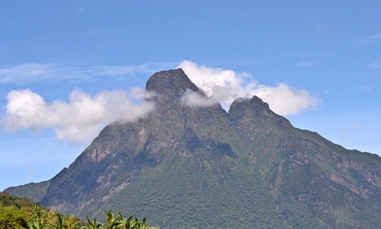
Karisimbi Mount
The tallest of the eight mountains, Karisimbi, is situated on the border between Rwanda and the Democratic Republic of the Congo. It is renowned for its snow-capped summit and stands at 4507 meters. The Kinyarwanda term “amasimbi,” which means “white shell,” is the source of the name Karisimbi. It describes the appearance of the white-topped peak of Karisimbi. Trekking the perilous highlands of Karisimbi requires physical strength and good health. This two-day adventure requires hiking to the summit in one day, staying overnight, then starting the descent the following day.
Mikeno Mount
At 4437 meters, Mt. Mikeno is completely inside the borders of the Congo and is the second-highest mountain in the Virunga mountains after Mt. Karisimbi. Virunga National Park, where the dormant volcano is located, is home to numerous mountain gorillas. The mountain is known as “Mikeno,” which translates to “poor,” due to its rugged, impassable slopes. Mountain Mikeno is one of the largest geographical features in the globe and is reportedly visible from the moon.
Mount Muhubura
Mt. Muhabura, which is shared between Rwanda and Uganda, is 4127 meters high. It takes six to eight hours to trek up and down this volcano in a single day. Since the villagers could see it from anywhere and it served as a guide for them on their journey home, the word “Muhabura” is derived from the Rufumbira language, which means “guide.” It offers breathtaking views of the Rwenzori Mountains and Lakes Edward and George on a clear day.
Bisoke Mountain
Since its most recent eruption in 1957, Mt. Bisoke, which lies between Rwanda and Congo, has been categorized as an active volcano. On clear days, one can enjoy the view of the spectacular Crater Lake at the top of this 3711-meter hill, which is sometimes covered in fog. It often takes four to six hours to walk to the summit and back. Until you reach the summit, the hike will lead you through a variety of plant species.
Mount Sabyinyo
Uganda, Rwanda, and the Democratic Republic of the Congo share the peak of Mount Sabyinyo, so once you’re there, you can enter all three countries using a single visa from the country where the journey started. In Rufumbira, a language related to Kinyarwanda, the jagged appearance of Sabyinyo’s top is compared to “old man’s teeth,” hence the name. Its slopes are home to the endangered mountain gorilla species, which are the main inhabitants of the Virunga National Park in the Democratic Republic of the Congo, the Mgahinga Gorilla National Park in Uganda, and the Volcanoes National Park in Rwanda.
Gahinga Mountain
Within Mgahinga Gorilla National Park, Mt. Gahinga rises 3474 meters above sea level. The term Gahinga, which means “pile of stones” in Kinyarwanda, refers to the many stones that are swept down to people’s fields and then heaped up to make room for cultivation. A swampy caldera on the summit of the strat volcano is shared by Rwanda and Uganda.
Mount Nyamuragira
Like Nyiragongo, Mt. Nyamuragira is an active volcano that is entirely contained inside the boundaries of the Democratic Republic of the Congo. It is 3058 meters above sea level. Its most recent eruption produced a fresh 500-meter-deep lava lake for the first time in 75 years. Although it is 3058 meters high, travelers cannot access it due to inaccessible roads and security concerns.

Nyiragongo Mount
Mount Nyiragongo is an active volcano in the Democratic Republic of the Congo that rises 3470 meters above sea level and has a 600-meter-deep lava lake. Since 1882, it has erupted 34 times, with the most recent one occurring in 2002. It is completely enclosed inside the Democratic Republic of the Congo‘s boundaries. Because of the stunning volcano lava lake, which offers breathtaking views at night, it is on many people’s trekking bucket list. It’s a strenuous but thrilling two-day journey, but be ready to climb the high mountain to reach your campsite on the first day, where you may leave your things and head to see the lava lake, which is visible at night. With the help of your guide and porters, you would hike down the following day.
Rwandan farmers and, in some areas, cattle herders make up the majority of the people living on the heavily populated plateaus from which the Virunga Mountains rise. Volcanoes National Park in northern Rwanda contains the southern sides of the central and eastern ranges; Mgahinga Gorilla National Park includes the Ugandan slopes of the Mgahinga Mountains; and the southern sector of Congo‘s Virunga National Park includes those portions of the mountains that are within Congo. Conservation protects species like the mountain gorilla and golden monkey, as well as the highland alpine vegetation.